Trails
in Cabanes
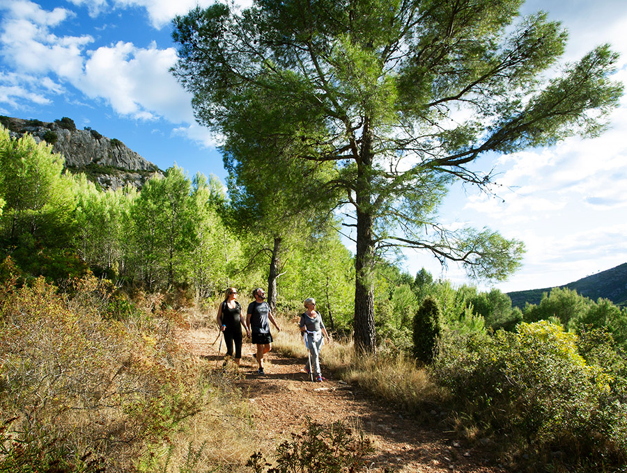
Cabanes gets you moving
Connecting with the earth, enriching our senses, observing the witching hour, crowning the summit, coasting downhill. Cabanes is the experience of reconnecting with the land through its hiking and cycling trails. Trails for all tastes and levels in nature’s embrace.
HIKING TRAILS
Les Santes Trail
Start: Les Santes Chapel (PR-CV-422).
End: Les Santes Chapel.
Elevation change: 172 m.
Distance: 4 km.
Difficulty: Low.
Estimated time: 1h 40 min.
Signposted trail.
Track: https://es.wikiloc.com/rutas-senderismo/ruta-9-circular-por-les-santes-12002102
This trail runs through the leafiest part of the Nature Reserve and starts on a dirt track in the direction of La Pobla Tornesa. Upon reaching a turn-off that would take you straight to the summit of El Bartolo, continue to the left along a path that soon starts to descend steeply until you reach a track that will take you back to Les Santes Chapel. A unique environment in one of the oldest geological areas in Valencian territory. You can reach it from the CV-148 road, which connects the towns of Cabanes and Oropesa, in the part closest to Cabanes. The entrance is signposted with an information panel.

El Bartolo and Les Santes
Start: Les Santes Chapel.
End: Les Santes Chapel.
Elevation change: 519 m.
Distance: 9.9 km.
Difficulty: Medium.
Estimated time: 6 h.
Track: https://es.wikiloc.com/rutas-senderismo/bartolo-les-santes-bartolo-15768582
Walk 500 metres along the road in the direction of Oropesa until you come to a signposted track to the right, which soon turns into a path. As you ascend, you will see the remains of the castle’s outer wall and, a few metres further on, the entire set of architectural remains. A route with changing landscapes and historical features on which you will discover the ancient fortress of Muslim origin. You can access it from the CV-148 road in the direction of the Los Madroños Rest Home.
Miravet Castle
Start: Miravet Fountain.
End: Miravet Castle.
Elevation change: 194 m.
Distance: 2.3 km.
Difficulty: Medium.
Estimated time: 3 h.
Track: https://es.wikiloc.com/rutas-a-pie/putjada-al-castell-de-miravet-cabanes-34006584
Walk 500 metres along the road in the direction of Oropesa until you come to a signposted track to the right, which soon turns into a path. As you ascend, you will see the remains of the castle’s outer wall and, a few metres further on, the entire set of architectural remains. A route with changing landscapes and historical features on which you will discover the ancient fortress of Muslim origin. You can access it from the CV-148 road in the direction of the Los Madroños Rest Home.
La Sal Tower 1
Start: Information Centre.
End: Information Centre.
Elevation change: 1 m.
Distance: 2.5 km.
Difficulty: Low.
Estimated time: 45 min.
Signposted trail.
Track: https://es.wikiloc.com/rutas-senderismo/ruta-roja-pn-prat-de-cabanes-40577963
A signposted trail on which you can enjoy the views offered by the original pebble barrier and discover a flora micro-reserve as well as some of the ornithological species typical of the area. The route begins at the Information Centre, located next to the Torre de la Sal Aquaculture Institute, where you can also discover all the peculiarities of this rich ecosystem and its great biodiversity.
La Sal Tower 2
Start: Information Centre.
End: Information Centre.
Elevation change: 1 m.
Distance: 6.5 km.
Difficulty: Low.
Estimated time: 1 h 40 min.
Signposted trail.
Track: https://es.wikiloc.com/rutas-senderismo/ruta-azul-pn-prat-de-cabanes-40829576
A signposted path that runs parallel to the coast in the direction of Torrenostra. Discover the fossil dunes, the impressive pebble barrier that runs almost uninterruptedly along the Nature Reserve, on a pleasant walk until you reach a beautiful sandy beach near the ruins of the old carabineer barracks. This trail also takes you into the wetlands on a final stretch that runs through marshes. You will come back filled with Mediterranean sensations!
Torrenostra
Start: Torrenostra village centre (south).
End: Torrenostra village centre.
Elevation change: 36 m.
Distance: 4.5 km.
Difficulty: Low.
Estimated time: 2h 35 min.
Signposted trail.
Track: https://es.wikiloc.com/rutas-a-pie/torrenostra-prat-de-cabanes-4475193
The trail starts in the direction of La Sal Tower and continues along a path that runs parallel to the coast. You will reach ‘Gola del Trenc’, where the drainage channels flow into the sea. From there, walk along the channels, cropland and the lagoons formed by peat digging. Discover species unique to the area, such as salt grass, and enjoy incredible panoramic views from the top of the viewpoints – a real environmental treasure!
Trail of the Towers
Start: Venda de Sant Antoni (KM 1004 N-340).
End: Venda de Sant Antoni.
Elevation change: 56.5 m.
Distance: 7.6 km.
Difficulty: Low.
Circular trail.
Signposted trail.
Track: https://es.wikiloc.com/rutas-a-pie/ruta-3-ruta-de-las-torres-desde-venta-de-san-antonio-ribera-de-cabanes-5143827
A signposted trail along which you can visit Cabanes’s old watchtowers: La Sal Tower and Carme Tower until you reach the Albalat Church-Fortress, Gats Tower and Carmelet, witnesses to the incredible stories of pirates and corsairs from the other side of the Mediterranean Sea who frequently attacked the coast from the Middle Ages to the 19th century. A trail that will take you through a pleasant landscape of fields and watchtowers.
Mortórum
Start: Mortórum Car Park.
End: Ferradura.
Elevation change: 85 m.
Distance: 1.1 km.
Difficulty: Medium.
Estimated time: 1 h.
Signposted trail.
Track: https://es.wikiloc.com/rutas-senderismo/cabanes-el-tossal-del-mortorum-un-yacimiento-de-la-edad-del-bronce-ibp-29-hkg-24017045
Ascent to Tossal del Mortórum, a hill in front of the great coastal plain of Ribera de Cabanes, where there is an Iberian settlement and a burial mound. The first part of the trail runs along a track between crops and pine woods, passing by an old lime kiln. After visiting the settlement, continue 265 metres along the path until you reach the burial mound and the summit of La Ferradura, one of the most iconic mountains in the Cabanes area. You can access it from the CV-146 road at km 4.5 and the trail is signposted and has information panels.
Workers’ Trail
Start: End of C/La Cava street (Cabanes).
End: La Ribera Cemetery.
Elevation change: 350 m.
Distance: 11.5 km.
Difficulty: Low.
Estimated time: 1 h 20 min.
Track: https://es.wikiloc.com/rutas-senderismo/cabanes-ruta-dels-treballadors-106829
A signposted path that links Cabanes with La Ribera de Cabanes where, a century ago, the locals used to go to work and earn a wage. The trail heads eastwards in search of the breeze from the Mediterranean Sea, which is the backdrop for many stretches of the trail. Along the trail there are numerous examples of traditional agricultural activity with fields full of fruit trees, pine forests and impressive dry-stone walls and buildings.
Walk around El Pinet
Start: Plaça Els Hostals square (Cabanes).
End: Plaça Els Hostals square (Cabanes).
Elevation change: 135 m.
Distance: 8.2 km.
Difficulty: Low.
Circular trail.
Track: https://es.wikiloc.com/rutas-senderismo/ruta-7-volta-al-pinet-cabanes-5143802
Starting from the square, the trail runs along Carrer Cronista Guillermo Andreu Valls street, passing by various points of tourist interest: the remains of the old Sant Antoni Gate, one of the entrances to the medieval wall and a house built with stones from the Roman Arch dating from the 2nd century AD. It then reaches the Calvary, on ‘Molinet de Vent’ hill. Continue until you reach a pine forest called ‘Els Pinets’, where the path will take you back to Cabanes passing by Mas del Morrudet.
Tour of Marmudella and ascent of Gaidó mountain
Start: C/Rabachol (Cabanes).
End: Cabanes.
Elevation change: 576 m.
Distance: 21.4 km.
Difficulty: High.
Estimated time: 5 h.
Track: https://es.wikiloc.com/rutas-outdoor/volta-a-la-marmudella-i-pujada-a-gaido-2144688
This trail runs through the Les Santes countryside, specifically the area known as Marmudella, and ends at the top of Gaidó, from where you can enjoy a fantastic panoramic view of Cabanes. Head along the path that climbs up to the calvary and continue towards the Les Santes mountains. At the Les Santes Chapel, go around Marmudella to join a path that runs parallel to the CV-10. Continue to the tunnel that crosses the road and on to the left, on a path that will take you directly upwards to Gaidó.